🚵 Biking at Mammoth in 2024 🏔️
- Barbara Levine
- Oct 22, 2024
- 13 min read
Updated: Mar 11, 2025
June-October, 2024
Written by Barbara Levine
🚵 1.0 Preface🏔️

We usually spend a week each month in Mammoth Lakes, California where we have a condo. Stan skis there during the winter and spring months. In the summer and fall, we ride our bikes on the many bike paths in the area.
August 2024: Stan & I are biking on the Eastern Town Loop at Mammoth. Mammoth Mountain is behind us.
On our four trips from June to October in 2024, we add hiking and exploring as well. The scenery is breathtaking everywhere we venture.

On two of our four trips, in June and October, Stan and I are on our own. On the other two trips, in August and September, we are led by our friend Gale who lives in Mammoth Lakes during the summers.
September 2024: Gale and Stan on a bike ride on the Eastern Town Loop at Mammoth
Stan skis with Gale during the winter months, and she knows all of the hiking and biking trails in the area. We have given her the nickname Ranger Gale.
🚵 2.0 Our Biking History – Then and Now🏔️
I don't remember ever having a tricycle or bicycle when I grew up on a farm in Michigan. It made no sense, because there were no sidewalks or bike paths to ride them on in the country. And besides, as the eldest of 11 children, bikes were an unnecessary expense. I always walked the 1 ¼ miles to and from my one-room country schoolhouse.

In the early '70s after my first marriage ended, I started riding bikes with a group from Hughes Space Systems Division where I worked between 1963-65. The earliest photo that I have of myself on a bike ride is when I took a date on a weekend ride with the group from Hughes in northern California in March 1973. There we biked the 17-Mile Drive from Monterey to Carmel and back.

The next photo that I have of myself riding a bike is in 1974 when I was 33 years old on on a bike ride through Napa and Sonoma Valleys in northern California.
You can read all about that trip in my missive titled, 🚵🏻♂️ Wine Country Safari – The Bike Ride We Crash, 1974 🚴♂️, by clicking on the photo on the left.
In 2018 when my dizziness became a safety issue while riding a bike, I switched to riding an adult Trike.
Below are a few biking photos of Stan and myself over the years.

Upper left: Stan is riding his first tricycle in The Bronx in 1940
Upper right: I am riding my bike with alpine gears in 1975 from San Francisco to Los Angeles
Lower left: I am riding my first tricycle (an adult Trike) in 2018 on the bike path in Manhattan Beach.
Lower right: I am still riding my Trike in August 2024 with Stan on a bike path at Mammoth
🚴♀️ 3.0 Biking in the Mammoth Area in 2024 🚵🏻♂️
We visit an amazing amount of places during our four trips to the Mammoth area from June to October of 2024, including 28 biking, hiking and exploring destinations.
There are several nice biking paths in the Mammoth Lakes area. Our Condo on Old Mammoth Road is our starting point and is not far from all of them. We ride our bikes on most of the biking paths more than once in 2024. There are also many dirt trails for mountain biking which my Trike cannot handle.
The table below summarizes our 11 biking destinations during the 18 full days that we are there.
Our Condo and 11 Biking Destinations in the Mammoth Area in 2024

The following map displays our Condo(1)* and our 11 biking destinations in red numerals.
* The nomenclature used when referring to an adventure destination in Destination(#), where # is a map point.

Biking Destinations 2-6 are in the immediate vicinity of the town of Mammoth Lakes, whereas Biking Destinations 8-12 and 16 are in the Lakes District (aka the Mammoth Lakes Basin) to the southwest of Mammoth Lakes.
🚴♀️ 4.0 Biking Around Mammoth Lakes in 2024 🚵🏻♂️
The primary bike paths in the vicinity of the town of Mammoth Lakes are the Town Loop and its three Spin-Offs, which are shown on Map 2 below.
• The 7.8 mile Town Loop is split into the Eastern Loops(2) (where three bike paths merge into one) and the Western Loop(6).
• Three Spin-Off bike paths from the Eastern Loops(2) lead to the Hayden Cabin/Mammoth Museum(3), the Mammoth Lakes Welcome Center(4), and the Shady Rest Park(5).

The Eastern Town Loops(2) are to the right of where Our Condo(1) is located, and the Western Town Loop(6) is to the left. The bike path along Lake Mary Road to the Lakes District starts on the far left and is covered in Section 5.
🚴♀️ 4.1 Biking the Eastern Town Loops & the Three Spin-Off Trails
In Map 2 above, there are three bike paths on the Eastern Town Loop(2) that start at different places and converge half-way around. The paths are easy riding with some small ups and downs.
Following are photos from our several rides along the Eastern Town Loop(2) as well as the three Spin-Offs(3, 4 & 5).

Top left: Stan is riding near Mammoth Middle School with Mammoth Mountain in the distance.
Top right: A colorful fish in a playground
Bottom left: The Volcom Brothers Skate Park
Bottom right: The Eastside Mill & Lumber Company with Mammoth Mountain in the distance

Top left: I am on my adult Trike and Stan is on his bike with Mammoth Mountain behind us
Top right: Zooming in on the left 0f the top left photo reveals Mammoth Rock (7) where we attempt to bike/hike to in October
Middle left: View of the mountains to the south with the aspens showing their fall colors in the distance
Middle right: Barbara & Stan with mountains in the background with snow left in June
Bottom left: Stan & Barbara with Mammoth Hot Creek in the far distance
Bottom right: Ranger Gale & Stan

Top left: The outside of the Hayden Cabin(3) (now the Mammoth Museum) on the first Spin-Off. The cabin was built in the 1920-30s, and each log had to be towed by car for 10 miles.
Top right: Stan standing in the living room of the Hayden Cabin(3)
Middle left: Barbara beside Wooly Mammoth outside the Mammoth Visitor Center(4)
Middle right: Stan & Barbara on the bike path to Shady Rest Park(5)
Bottom left: Stan riding on the bike path to Shady Rest Park(5)
Bottom right: Stan standing in one of the athletic fields at Shady Rest Park(5). Our Boxer Henry is beyond him. We bring our dog here every morning and evening when he travels with us so he has room to romp and play with other dogs off-leash.
The fascinating history of the Hayden Cabin(3) is described below:

🚴♀️ 4.2 Biking the Western Town Loop(6)
Refer back to Map 2 in Section 4.0 to see the route of the Western Town Loop(6). Starting at our Condo(1), we bike south on Old Mammoth Road and take the tunnel under it to reach the Mammoth Creek Park. A short distance away is the LA Kings Ice at Mammoth Lakes, a large indoor ice skating rink that features public ice skating and lessons from late fall to early spring.

Top left: Stan is on his bike in front of the LA Kings Ice at Mammoth Lakes in June
Top right: Inside the LA Kings Ice at Mammoth Lakes in June when the ice rink has converted off-season from an ice rink into a multi-sport center
Bottom left: Mammoth Creek Park in October
Bottom right: Mammoth Creek viewed from the bike path bridge in June
We pass by the historic Knight Wheel, a relic from Mammoth's brief gold rush days in the late 1800s.

Top left: Stan on his bike in front of the historic Knight Wheel in August
Top right: This log cabin just north of the Knight Wheel was built in the early 1900s.
Bottom left: The inscription on a plaque by the Knight Wheel
Bottom right: Another view of the Knight Wheel. The structure behind it housed the generator. Built in the early 1900s, it is the oldest known building in Mammoth.
The bike path continues west along Old Mammoth Road with views of Mammoth Mountain and Mammoth Rock.

Top: View of Mammoth Mountain in June from the bike path along Old Mammoth Road
Middle: Stan on the bike path in August with.a view of Mammoth Rock ahead of him in the distance
Bottom: Close-up view of Mammoth Rock from the bike path in October

We always ride to the western-most point of the bike path at Eagle Lodge, which is at the bottom of Chair 15 – the lowest chairlift on the mountain at an elevation of 7,953'. The elevation of our condo is 7,880' and the elevation of the top of Mammoth Mountain is 11, 053'.
I am on my Trike by the large bronze eagle statue in front of Eagle Lodge in October. Mammoth Mountain is in the distance.
On our return route, we usually take back streets to access the bike path that runs along Main Street to Old Mammoth Road. After that, we have a short ride on the sidewalk to reach our Condo(1).
🚵🏻♂️ 5.0 Biking to the Lakes District
Biking to the Lakes District to the southwest of Mammoth Lakes is the longest and most strenuous of our biking adventures. Starting and ending at our Condo(1), it includes riding the Western Town Loop(6) as well as the long uphill ride to the Lakes District (aka the Mammoth Lakes Basin) to the southwest of Mammoth Lakes.
Map 3 below shows the bike path from where it reaches Twin Lakes(8) (top center) to Lake Mary(9), Lake Mamie(10), Twin Falls Overlook(11), and the end point at Horseshoe Lake(12). We also bike along the road from Lake Mary(9) to the Mammoth Consolidated Mine(16).

Map 4 below shows our bike route in red starting and ending at Our Condo(1) as well as our distance traveled and the elevation change. Once we leave the town of Mammoth Lakes, the bike path parallels Lake Mary Road with a detour loop along Twin Lakes(8).
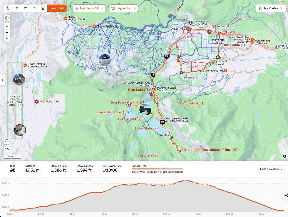
Maps 3 and 4 also show the locations of two of the outstanding geographic features in the area – Mammoth Rock and Crystal Crag.*
* In geography, a crag is a steep, rugged, and high mass of rock that juts out from the surrounding land. Crags are often found on cliffs and mountains, and can be covered with steep rock faces. Crystal Crag is primarily composed of solid granite, unlike the more varied volcanic rock found in the wider Mammoth Lakes area, including Mammoth Rock.
The round-trip distance from Our Condo(1) to all of the biking destinations in the Lakes District is nearly 18 miles, and the elevation change is nearly 1,600 feet.
Following are photos along the route of and at each of our biking destinations in the Lakes District.
🚵🏻♂️ 5.1 Biking the Lakes Basin Path Up to Twin Lakes(8)
The Lakes Basin Path is a paved bike path that starts in Mammoth Lakes and runs parallel to Lake Mary Road, climbing steadily for 5.3 miles to Horseshoe Lake at the upper end. It offers stunning views of the surrounding mountains, including the Sherwin Range and Mammoth Mountain.
The first portion of the Lakes Basin Path to Twin Lakes(8) offers the most stupendous panoramic views.

Upper left: Stan, myself and Gale with the Sherwin Range behind us. Mammoth Rock sticks up on the right.
Upper right: Stan and I on the bike path half-way up Lake Mary Road. Mammoth Lakes is in the distance below us, and Lake Crowley can be seen in the far distance below the White Mountains.
Lower left: Stan and I are approaching the Lakes District in the distance with Crystal Crag on the left.
Lower right: Mammoth Creek is flowing down from where it starts at Twin Lakes(8) above us. The water in Mammoth Creek travels through Mammoth Lakes and south 300 miles to Los Angeles, with help from a man-made delivery system called an aqueduct.
🚵🏻♂️ 5.2 Biking from Twin Lakes(8) to Lake Mary(9)
Twin Lakes(8) is the entrance to the Mammoth Lakes District (aka Lakes Basin). Most of the lakes here were carved by massive glaciers that moved over the landscape during ice ages.
A very active geologic past of fire and ice created this Basin. Now in a period of unrest, Mammoth Mountain last blew its lid about 50,000 years ago.
Sticking out of the ground like a big granite tooth, Crystal Crag at 10,305 feet is a stunning feature viewed from most of the lakes. It is a favorite of rock climbers and hikers. Click on the title of my missive, 🥾 Hiking to Crystal Lake Beneath Crystal Crag, Oct. 2024 ⛰️, to read all about when Stan and I hiked there in October 2024.

Upper left: Stan and I at the northern end of Twin Lakes(8) with Crystal Crag sticking up in the far distance to the south and Twin Lake Falls barely visible below it to the right.
Upper right: Further along the bike path, we detour down to ride alone Twin Lakes(8). This is the view from Tamarack Lodge looking across Twin Lakes(8) toward a feature called the Hole in the Wall*.
* The Hole in the Wall above Twin Lakes(8) was created when the rock eroded to create an arch. Many people mistake this formation for a lava tube, but the tunnel is actually an eroded gully with its roof still intact.
Lower left: Gale, Stan and I are at a viewpoint on the bike path to Lake Mary(9). Behind us is Mammoth Mountain on the left and the Hole in the Wall just above Stan and my heads.
Center: View of the Hole in the Wall from its entrance on the opposite side in the winter. Just imagine skiing through it yourself!!**
** Experts Only! During winter, the Hole in the Wall is considered an out of bounds backcountry ski run and is only recommended for the most advanced skiers. Words like treacherous, aggressive and double black diamond are used to describe the adventure. During warmer months, the trail to the landmark is challenging with loose and unstable rock.
Stan's daughter Tiffany and his granddaughters Jessica and Juliet have all skied through the Hole in the Wall.
Lower right: Stan is on the bike path on the way to Lake Mary(9). On the right is the Mammoth Lakes Pack Outfit from where we made a horsepacking trip up to Duck Lake and Purple Lake for a week in 1993.
🚵🏻♂️ 5.3 Biking from Lake Mary(9) to Lake Mamie(10) and the Twin Lakes Overlook(11)
The views of Crystal Crag across Lake Mary(9) and Lake Mamie(10) are most impressive, as is standing directly above Twin Falls from the Twin Lakes Overlook(11) as the water tumbles down 300 feet into Twin Lakes(8).

Top: Stan and I by Lake Mary(9) with Crystal Crag rising prominently across the lake
Bottom left: At the top of the Twin Lakes Overlook(11), a view back at Crystal Crag above Lake Mamie(10) with the water from the lake pouring over a spillway on its way to Twin Lakes(8)
Bottom right: Stan and Gale at the top of the Twin Lakes Overlook(11) right above where Twin Lake Falls tumbles down 300 feet into Twin Lakes(8)

🚵🏻♂️ 5.4 Biking from Lake Mamie(10) to Horseshoe Lake(12)
The bike path levels out on the last section from Lake Mamie(10) to Horseshoe Lake(12). As we approach the bike path's end at Horseshoe Lake(12), I am always struck by the number of dead trees around the lake.

Top left: The backside of Mammoth Mountain is in the background above the parking lot at Horseshoe Lake(12) with lots of dead trees
Top right: Stan and Gale having lunch above Horseshoe Lake(12)
Bottom right: View of Horseshoe Lake(12) with dead trees trunks that have been sawed off

🚵🏻♂️ 5.5 Biking to the Mammoth Consolidated Mine(16)

We backtrack down the bike path from Horseshoe Lake(12) to Lake Mary(9) where we leave the bike path to pedal along Lake Mary Road and then up the road to Coldwater Creek Campground. At the end of the campground, an easy, half-mile dirt path starts to the Mammoth Consolidated Mine(16).

Today the site includes the original miners' bunkhouses, mining offices, assay office, the Mahan cabin, a schoolhouse, a mill, and up the slope, the remains of a diesel-powered ore-processing mill and mine shafts.

Top left: Outdoor toilet for two
Top right: Stan and Gale beside Arch Mahan's cabin
Bottom left: The 100 HP Ingersol Rand diesel engine stands out amongst the clutter in the remains of the ore processing mill.
Bottom right: Miners' cabin
🚵🏻♂️ 6.0 Related Missives
I previously posted a missive about our adventures on our trip to Mammoth in June 2024. In addition to exploring by car, we biked the Eastern Town Loops and the three Spin-Off Trails.
It is titled, 🚙 Stranded in the Wilderness with a Flat, June 2024 🛞. You can read it by clicking on the photo below.

🚵🏻♂️ 7.0 Epilogue 🏔️
This missive has summarized our rides to 12 biking destinations in the Mammoth area over the 18 full days that we were there in June, August, September and October of 2024.
There are not many more bike rides you can experience in the area that don't involve riding on the side of roads or on off-road dirt trails.


Comments